

The proposed route for the ION LRT coming to Cambridge has been announced and now the conversation begins anew in town. I think one of the prevailing thoughts locally on this project has been that it was possibly a pipe dream and that Phase 2 would never actually come to Cambridge. It’s great to see progress being made as planning on phase 2 moves forward. I believe viable transit throughout Waterloo Region is very important. The idea that you could viably commute to KW in a reasonable amount of time without driving is definitely appealing. As someone who works in the tech sector, it’s important to have those types of amenities, even if it’s going to take another decade to come to fruition. With that said I had a few ideas to spitball on the whole ION project coming to Cambridge.
Additional Stops
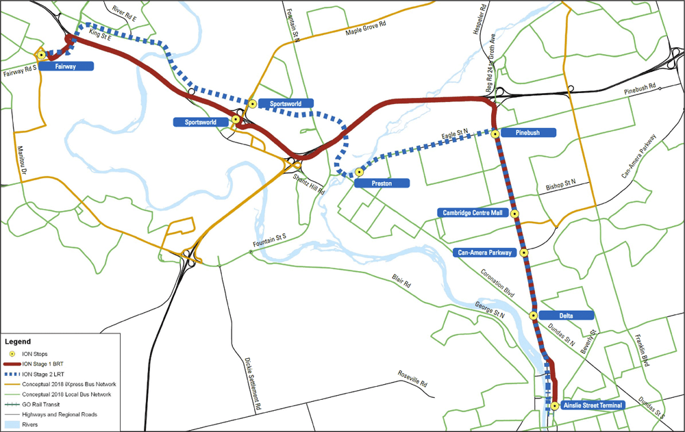
The thing I notice when it comes to the Phase 1 route versus the Phase 2 route it definitely feels like the Cambridge route is a lot more sparse than the KW route. That route features 19 stops, compared to just 7 on the Cambridge route. And very little of it actually goes near areas people actually live. Much of the route passes through industrial parks or commercial areas, which begs the question, is this meant to move people to jobs and shopping in Cambridge, or is it to move people from Cambridge to employment opportunities in KW? When looking at the route I could definitely see making a case for stops near Toyota, as well as between the Delta and the Ainslie Street terminal.
Now before I get too far into this I will state that I do actually live pretty close to the proposed route down on Eagle Street. This project would definitely impact myself and my neighbourhood as a whole. I’m not necessarily against the route going down Eagle, but I do feel there should be a stop at the corner of Concession Rd/Speedsville Rd and Eagle. My reasoning behind this is living in the closest neighbourhoods to Hespeler Road and the proposed Pinebush/Hespeler stop. According to Google Maps it would take 23 minutes to walk to this stop from Eagle Valley/Nantucket Village neighbourhood, compared to 13 minutes to a Concession Rd stop. As I mentioned, I live about as close as you could get to that stop, everyone else would be walking even further as you get deeper into the Langs Farm neighbourhoods. All the area around the Pinebush stop is no man’s land, with really no residential anywhere near North, East or South of there, with loads of big industrial lots, the 401 as well as the Smart Centre shopping area.
Mall To Mall To Mall
Ever since this LRT debate began in this region I’ve wondered this. Why exactly does the LRT run from the Conestoga Mall to Fairview Mall, yet in Cambridge the intent is to run the route all the way into Downtown Galt? The idea of running the route from one mall to the next had been met with a certain amount of derision, but I can understand the thinking. The malls are all well connected to transit. This makes them natural hubs to catch a bus to the rest of the city. To me building the LRT into historic Downtown Galt seems like overkill. As it stands the iXpress takes 9 minutes to get from the Ainslie terminal to the Cambridge Centre. It just seems silly to run pretty much the length of Hespeler Road then into Galt. Get the LRT to the Cambridge Centre transit hub and save a good chunk of project cost. As it stands there are still large swaths of Cambridge that won’t have direct access to the LRT(I’m looking at you Hespeler, and even the bulk of the Preston corridor), much the same as if you lived in West Kitchener.
With that being said, I believe much of the LRT route planning is also informing much of the development planning in Galt. The multiple condo projects, the Gaslight District, The Old Post Office project, they all fit together in a larger picture of the future direction of Cambridge. Running the route into Galt may be something I don’t agree with, but I do think it’s part of the master plan to be able to get North/South through Waterloo Region. This area seems to just budding as far as an economic driver for Ontario as a technology hub.
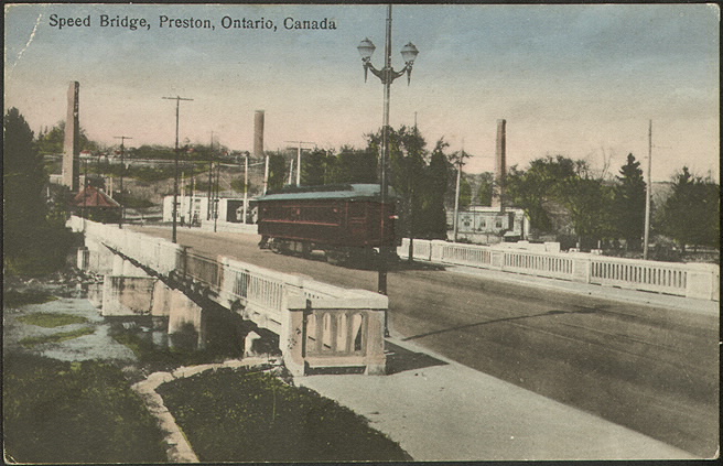
Maybe Through Preston Instead?
I published this post and instantly got some feedback on Twitter on the topic.
@cbridgeca Why would you not have a stop at Cambridge Memorial? The plan seems to benefit business, not make travel easier for residents.
— Christine 🍁 (@DIY1959) February 27, 2017
This was something I waffled on adding to this post since it was a somewhat contradictory idea to the couple others I presented, but I’ll go with it. I think the LRT would be more viable going through Preston than up Hespeler Road. Preston was literally the route with which the Grand River Railway ran through town. Much of this route is still quite accessible down Coronation with the wide boulevards down the middle of the street. As mentioned in the tweet, this does go right by the hospital, which of course is a big plus for certain residents of the city. Through Downtown Preston is trickier, but not unworkable.
Just throwing ideas out here, but would it almost make more sense to create a route that looped down Eagle to Hespeler Road to the Delta then back through Preston? It would definitely cost more, but it might actually make more sense for a city as weirdly laid out as Cambridge.
Have Your Own Ideas For Getting Around Cambridge?
The City is looking for feedback on their transportation master plan, fill out this survey to take part. Or feel free to leave a comment below.
@cbridgeca @eleanor70001 Reminder to all……Don’t forget to attend the consultation meetings this week! pic.twitter.com/21CPUO46Xq
— Christine 🍁 (@DIY1959) February 27, 2017


“Maybe Through Preston Instead?”
Have you read the public consultation documents? The preliminary preferred route does indeed go through Preston. If you’re going off the old map that you put at the top of your article, you’re working outdated information.
The route that has been chosen for the preliminary, as well as that old, original proposal in the map, the choice is made on volume of traffic, both public transit and cars, in what is known as the Central Transit Corridor which was first identified in the 1970s as being where most people go to and from, and how to encourage densification along that corridor. More people travel to and along Hespeler Road than Ling St. in Preston.
“As it stands there are still large swaths of Cambridge that won’t have direct access to the LRT(I’m looking at you Hespeler, and even the bulk of the Preston corridor), much the same as if you lived in West Kitchener.”
It’s not the point of an LRT route for everybody to have direct access to it. You wouldn’t complain that not everybody has “direct access” to a single individual route, that would just be silly. Just like how people connect to Route, or the iXpress routes by getting on another bus and going to a transfer point, they will do the same for the LRT.
I pulled that map direct from the Regions website and the PDFs they have provided. If the info online isn’t accurate, it’s the most up to date stuff I have seen personally. If it’s incorrect could you point me to the updated resources? I intended to go to the consultation last night but unfortunately had a sports conflict. I’m going to see about going to the Newfoundland Club tonight.
My point about Preston wasn’t necessarily about putting the route straight through Preston, it was about creating a triangular route down Eagle to Hespeler to the Delta then back through Preston to go back North to Kitchener. As I did mention in the article these were more loose ideas and may not all fit together.
I realize that an LRT isn’t meant to service ever nook and cranny of the region, it’s essentially to get North/South within Waterloo Region, hence why one might question why the route takes a detour up to Hespeler Road. The idea of intensifying population along Hespeler Road is rather odd since there is currently very little population that could claim to even be a 5 minute walk from Hespeler Road. I don’t really get the impression the types of jobs on Hespeler Road are the ones that people are commuting from KW to work. So if you’re not getting commuters coming South that need to get to Hespeler Road, it feels like a detour if you were say living in Galt and commuting to KW.
At the end of the day it’s great we’re talking about the LRT and the future of Cambridge and Waterloo Region. Ideally I’d love to see a time when it would actually be viable to commute into KW without it being a hassle and easier to just drive there.
The PCC docs can be found at http://rapidtransit.regionofwaterloo.ca/en/stage2ION/Public-Consultation-Documents.asp and the up-to-date route proposals can be found on page 8 of http://rapidtransit.regionofwaterloo.ca/en/stage2ION/resources/RT-ION-Information-package-2-feb2017temp-finalD.pdg.pdf and page 21 of http://rapidtransit.regionofwaterloo.ca/en/resourcesGeneral/FINAL_Stage-2-ION-PCC-No.-2-Display-Boards_reduced2.pdf and both of which were released around the 10th of February, if I remember correctly.
“it was about creating a triangular route down Eagle to Hespeler to the Delta then back through Preston to go back North to Kitchener. As I did mention in the article these were more loose ideas and may not all fit together.”
Do you mean like a huge version of the split-loop around Downtown Kitchener? That wouldn’t work very well because you couldn’t got back north down the same side you came south on. That would be a real PITA for people who need to go that opposite way because it’s far too wide to walk across, unlike DTK. 1,991 metres (or 25 minutes walk time) along Bishop according to my mapping software.
Or do you mean bidirectional on both sides? Then you’re significantly increasing cost of Stage 2 because Coronation+King would really be a second whole route in and of itself with all the costs for construction and extra LRVs that would imply.